Training course on GIS and Remote Sensing for Renewable Energy
Training Course on GIS and Remote Sensing for Renewable Energy is designed to equip professionals with the skills necessary to leverage these technologies effectively in the renewable energy sector.
Course Overview
Training Course on GIS and Remote Sensing for Renewable Energy
Introduction
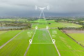
Geographic Information Systems (GIS) and remote sensing technologies are pivotal in the planning, development, and management of renewable energy projects. By providing spatial analysis and data visualization capabilities, these tools enable energy professionals to optimize site selection, assess environmental impacts, and enhance resource management. Training Course on GIS and Remote Sensing for Renewable Energy is designed to equip professionals with the skills necessary to leverage these technologies effectively in the renewable energy sector.
Participants will explore the fundamentals of GIS and remote sensing, including data acquisition, analysis techniques, and applications in renewable energy. The course will cover various use cases, such as solar and wind resource assessment, land use planning, and environmental monitoring. Through real-world case studies and practical exercises, attendees will gain insights into the challenges and opportunities associated with integrating GIS and remote sensing into renewable energy projects. By the end of the course, participants will be well-prepared to utilize these technologies to enhance the efficiency and sustainability of renewable energy initiatives.
Course Objectives
- Understand the fundamentals of GIS and remote sensing technologies.
- Analyze spatial data and its relevance to renewable energy projects.
- Evaluate remote sensing methods for resource assessment.
- Explore GIS applications in land use planning for renewable energy.
- Assess environmental impacts using GIS and remote sensing.
- Investigate data acquisition techniques for renewable resources.
- Discuss best practices for integrating GIS into energy planning.
- Identify challenges and barriers to GIS implementation.
- Develop skills in data visualization and analysis tools.
- Create actionable plans for utilizing GIS and remote sensing.
- Examine case studies of successful GIS applications in energy.
- Explore future trends in GIS and remote sensing technologies.
- Assess the economic implications of using GIS in renewable energy projects.
Target Audience
- Energy professionals and engineers
- GIS specialists and analysts
- Project managers in renewable energy
- Environmental scientists and researchers
- Policy makers and regulators
- Graduate students in geography, energy, or environmental studies
- Non-profit organization leaders focused on sustainability
- Industry representatives in energy technology
Course Duration: 10 Days
Course Modules
Module 1: Introduction to GIS and Remote Sensing
- Overview of GIS concepts and terminology.
- Importance of remote sensing in energy applications.
- Key components of GIS technology.
- Current trends in GIS and remote sensing.
- Case studies highlighting successful applications.
Module 2: Spatial Data Analysis
- Understanding spatial data types and sources.
- Techniques for data manipulation and analysis.
- Evaluating data quality and accuracy.
- Tools for spatial analysis in renewable energy.
- Real-world examples of spatial data applications.
Module 3: Resource Assessment using Remote Sensing
- Overview of remote sensing methods for energy resources.
- Techniques for assessing solar and wind resources.
- Evaluating satellite imagery and aerial data.
- Analyzing temporal data for resource monitoring.
- Case studies on resource assessment projects.
Module 4: GIS Applications in Land Use Planning
- Importance of land use planning in renewable energy.
- Techniques for site selection and feasibility studies.
- Evaluating environmental constraints using GIS.
- Integrating socio-economic factors into land use planning.
- Case studies on successful land use planning initiatives.
Module 5: Environmental Impact Assessment
- Overview of environmental impact assessment (EIA) processes.
- Using GIS and remote sensing for environmental monitoring.
- Techniques for assessing habitat and biodiversity impacts.
- Evaluating land use changes and their implications.
- Case studies on EIA in renewable energy projects.
Module 6: Data Acquisition Techniques
- Overview of data acquisition methods for renewable resources.
- Understanding satellite and aerial imagery sources.
- Techniques for ground truthing and validation.
- Evaluating the role of drones in data collection.
- Case studies on innovative data acquisition methods.
Module 7: Integration of GIS in Energy Planning
- Best practices for integrating GIS into energy planning processes.
- Developing GIS-based decision support systems.
- Engaging stakeholders in GIS applications.
- Discussing the role of GIS in policy development.
- Case studies on GIS integration in energy planning.
Module 8: Challenges and Barriers to GIS Implementation
- Identifying common challenges in GIS deployment.
- Discussing technological and financial barriers.
- Evaluating data privacy and security concerns.
- Strategies for overcoming implementation obstacles.
- Real-world examples of challenges faced in projects.
Module 9: Data Visualization and Presentation
- Importance of data visualization in GIS applications.
- Techniques for effective map creation and design.
- Tools for visualizing spatial data and analysis results.
- Discussing best practices for presenting findings.
- Case studies on impactful data visualization.
Module 10: Future Trends in GIS and Remote Sensing
- Exploring emerging trends in GIS and remote sensing technologies.
- Analyzing the impact of AI and machine learning in spatial analysis.
- Discussing the potential of cloud computing in GIS applications.
- Evaluating future directions for remote sensing in energy.
- Case studies on innovative GIS projects
Module 11: Economic Implications of GIS in Renewable Energy
- Assessing the cost-benefit analysis of GIS investments.
- Evaluating economic impacts on project feasibility.
- Discussing funding opportunities for GIS initiatives.
- Analyzing the role of GIS in optimizing project costs.
- Case studies on economic success stories.
Module 12: Creating Actionable GIS Plans
- Developing actionable plans for GIS implementation in projects.
- Setting measurable goals and objectives.
- Engaging teams and stakeholders in planning processes.
- Monitoring progress and adapting strategies over time.
- Presenting GIS plans for stakeholder approval.
Training Methodology
- Interactive Workshops: Facilitated discussions, group exercises, and problem-solving activities.
- Case Studies: Real-world examples to illustrate successful community-based surveillance practices.
- Role-Playing and Simulations: Practice engaging communities in surveillance activities.
- Expert Presentations: Insights from experienced public health professionals and community leaders.
- Group Projects: Collaborative development of community surveillance plans.
- Action Planning: Development of personalized action plans for implementing community-based surveillance.
- Digital Tools and Resources: Utilization of online platforms for collaboration and learning.
- Peer-to-Peer Learning: Sharing experiences and insights on community engagement.
- Post-Training Support: Access to online forums, mentorship, and continued learning resources.
Register as a group from 3 participants for a Discount
Send us an email: [email protected] or call +254724527104
Certification
Upon successful completion of this training, participants will be issued with a globally recognized certificate.
Tailor-Made Course
We also offer tailor-made courses based on your needs.
Key Notes
- Participants must be conversant in English.
- Upon completion of training, participants will receive an Authorized Training Certificate.
- The course duration is flexible and can be modified to fit any number of days.
- Course fee includes facilitation, training materials, 2 coffee breaks, buffet lunch, and a Certificate upon successful completion.
- One-year post-training support, consultation, and coaching provided after the course.
- Payment should be made at least a week before the training commencement to DATASTAT CONSULTANCY LTD account, as indicated in the invoice, to enable better preparation.